Route: Reverse RAM
Distance: 28 miles
Elevation Gain: 7,500 feet
Time: 9:19
Weather: 9 degrees, 30+mph winds, snowing, arctic
Photos by: Matt Kirk, Charlie Roberts, Sultonic
Video: Matt Kirk
 The forecast kept getting worse. But I knew a winter ascent of the Roan Adventure Marathon was a must do, its been on my list for a while, and I was itching for some climbing. Wilma, Beth, Charlie, the Kirk and I rolled out of 19E and the AT at 8:40am. It was snowing and temperatures at the start were just under freezing. It felt warm, and I thought I was carrying more gear that I needed.
 The night before, we decided to camp out at Roan High Knob Shelter. At 6,285 feet, its the highest shelter on the AT. We picked a perfect day for the first time experience of being in that shelter, along with 5 other backpackers. That night we discussed strategy on a winter RAM with possible sever weather and forecasters calling it "arctic!" After much contemplation, we opted for the early am hike out of the shelter and drive down to 19E vs. starting at Carvers Gap. We descended down TN143 cautiously in the dark as it was covered in a thin layer of powder. Ate some breakfast, and pulled into the hardware store where we came up with the idea of wanding the trail on the balds should there be a white out condition. This would help us with route finding on the return.

I quickly shed a few layers after we started as it felt warmer once we were out of the wind, and in the thick of the trees. I worked hard to catch up with most of these guys, and thus worked up a sweat, which quickly turned into ice as I climbed up into the higher elevations. I felt like I was wearing a shirt made out of ice! I could toerate the temperatures, but knew I would end up with freezer burn if I didnt do something about it. By the time I reached Doll Flats I put on my light weight down jacket. I knew this wold warm me up fast, but also knew once I put it on it was not coming off.

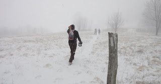
As we pushed up higher, it got colder and windier. The wind was leathal on top of Hump Mountain (5,587 ft) with its ridges fully exposed. The wind was easily 30 mph here, and temps were in the teens if now lower on the way up. I was a little thrown off with what appeared to be a new section of fence on the AT. I thought perhaps we took a wrong side trail, so we backtracked a littel in the brutal wind. The white AT blazes were camoflouged in the snow. Thru this reshuffle, both Wilma and Beth decided to descend. This was smart choice, and one I almost made for myself. Charlie and I decided to retrace back to the AT and keep pushing thru this weather.
 I was happy to reach Bradley Gap and get into the cover of the trees and escape the wind. I remembered the several days we camped at 17,200 ft. on Denali looking at wind plums higher up on the summit and deciding to take a zero day on what otherwise was a nice balmy. The wind can kill you at these temperatures, and surley can give you frostbite, frostnip, or windburn. Covering any exposed skin here is crucial. I was unable to do this because I lent my balaclava out, which I paid the price for.
 We climbed up another hill and passed Little Hump (5,460 ft.), then downhill again all the way to the shelter just before the big climb. Here I realized I was dehydrated as all my bottles froze, and there was no way to get any hydration. I thought to myself I should turn around now while I had the chance. It kept getting colder, and windier. The weather was not improving. After a little encouragment from Charlie, we decided to keep pushing, and on we climbed.
 It took forever to climb up to Grassy Ridge Bald (6,189 feet), but I was happy to see a small stream of water trickeling close to the summit. I knew I would try to refill my bottles on the way down. Once we were on the balds again, the wind would pick up and freeze up my buff and gloves, and really send a chill to the body. But the Balds higher up here were less brutal than the Hump Balds, which I have nightmares about now. We passed the frozen sign that says Janes Bald (5,807 ft.) and pushed on to Round Bald (5,826 ft.) which is where we camp out the night before the summer RAM. Here we saw the Kirk, who was jovial and moving well. The sun looked like it wanted to come out here, but it never really did. It was just before 1pm, and I knew we were close to Carvers Gap. Matt encouraged us to go the distance, and would catch up with us at the finish. We made a dash for Carvers Gap, where a few 4 wheel drive rides were hanging out.
 On the return, the weather progressivly got worse. Charlie clocked 9 degrees on his watch. I was never able to refil my bottles, and when attempting to do so my gloves got wet and the water froze immediatly in the bottle. I balled up my hands inside the wet gloves to not let them go numb. My buff froze on and off, and blowing hot breath onto them did noting. My ear lobes were exposed to the sever winds on Hump, and both ears are blistered now, but are healing. I feared the balds with the winds, but we made it back, and out alive. What a winter adventure? These conditions were by far some of the worst I have seen in Western North Carolina, and its easy to go underprepared. It goes to show you some of these high peaks can be brutal!


Distance: 28 miles
Elevation Gain: 7,500 feet
Time: 9:19
Weather: 9 degrees, 30+mph winds, snowing, arctic
Photos by: Matt Kirk, Charlie Roberts, Sultonic
Video: Matt Kirk


I quickly shed a few layers after we started as it felt warmer once we were out of the wind, and in the thick of the trees. I worked hard to catch up with most of these guys, and thus worked up a sweat, which quickly turned into ice as I climbed up into the higher elevations. I felt like I was wearing a shirt made out of ice! I could toerate the temperatures, but knew I would end up with freezer burn if I didnt do something about it. By the time I reached Doll Flats I put on my light weight down jacket. I knew this wold warm me up fast, but also knew once I put it on it was not coming off.

As we pushed up higher, it got colder and windier. The wind was leathal on top of Hump Mountain (5,587 ft) with its ridges fully exposed. The wind was easily 30 mph here, and temps were in the teens if now lower on the way up. I was a little thrown off with what appeared to be a new section of fence on the AT. I thought perhaps we took a wrong side trail, so we backtracked a littel in the brutal wind. The white AT blazes were camoflouged in the snow. Thru this reshuffle, both Wilma and Beth decided to descend. This was smart choice, and one I almost made for myself. Charlie and I decided to retrace back to the AT and keep pushing thru this weather.


Whoooa?


1 comment:
Sultan, good report. Thanks for inspiring me to get out there.
Post a Comment