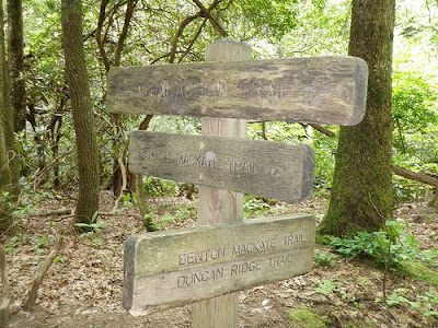
The five of us drove down to Springer Mountain, GA. Kevin Lane, Matt Kirk, Carl Laniak, Charlie Roberts and I had planned to run/hike the entire length of the Benton MacKaye Trail. We roundavoued with Josh Wiesner who helped us tremendously with logistics on the ground and on the website (
http://runthebmt.wikispaces.com/). He also took photos and video of the first day.
We made it to the summit of Springer just after 10pm on Thursday May 21, 2009. Everyone laid out their sleeping gear and passed out. We got up just after 6am and a few people were starring at my sleeping bag which was an item of luxury for most.

We all took off at 8am and headed North. All of us had planned the entire week off from our lives to tackle this monstrous challenge. Yesterday someone mentioned that there was 70,000 feet of cumulative elevation gain on the BMT. That was news to me, but I was willing to give it a shot. Me and Charlie ran together for the first 20 miles or so. The plan was to average 3 mph, how hard is that right? It’s a lot harder than you think over several days.
At mile 21.4 we both reached a campsite with a side trail for water. Both me and Charlie needed water, I had been without it for almost two miles. The side trail descended steeply and Charlie decided to move on and I went down for some hydration. The water source wasn’t the best, and it was a tiny trickle that was hard to retrieve, but I managed to get some water and filled up what I could only to hike back up the steep trail I just descended.
At mile 25, Payne Gap, I passed Charlie as he would search for water. We later met again near mile 30 where I was refilling my bottle for water at a spring. Charlie never found water at Payne Gap and was hiking dehydrated. He filled up on water and I kept moving along. We both managed to make it to Aska Road at the same time because I made a wrong turn which cost me 20 minutes or so. This was the first check point and it was 7:45pm. I was happy to see a deli ahead which both Charlie and I stepped into. The owner was in a hurry and had already closed down shop, but managed to make me a turkey sandwich. It was there I barrowed his phone to call in (listen to audio). Charlie had planned to hike the entire trail unsupported, so he kept moving along. I stayed behind and gobbled up my turkey, a coke, and an ice cream sandwich.

From there I marched on the asphalt for over 3 miles. The asphalt did a number on my feet and I decided to take a 10 minute break at mile 40 at the Fall Branch Falls side trail. It was dark at this point but the weather was still warm. I took off my shoes and dipped my feet in the cold stream until they were numb. I dried them off, applied some hydropel and kept trucking along.
I had not seen Carl at all and I was wondering how he was doing. Matt, Kevin, and Charlie were all ahead of me so the night hiking began. I was moving slowly, but made my way up to Scroggin Knob which is where I saw Kevin laying on the side of the trail getting some rest. We exchanged hellos and I kept going. Just before Laurel Creek I saw Charlie preparing himself to sleep in his hammock. Just passed the creek I lied down, turned off my headlamp, and rested for half an hour or so. The bugs bothered me, so I got up, filled up my water bottles and thought I could continue for a few more hours or so. After 100 meters I changed my mind and pulled up my bivy and went to sleep, it was 1:30am. A few hours later Charlie rolled by. I decided to stay sleeping until the sun came up. Both Kevin and I were on the trail around the same time and we hiked up to the only shelter the BMT has at mile 50. Kevin was moving a little faster so I stopped to get water and we parted ways.
The trail was amazing. The weather was humid and slightly warmer than I thought it would be. Last night when I slept in the bivy I used my sleeping bag as a pillow as I didn’t need it. Many thoughts ran thru my head, it was an emotional roller coaster. Mentally I began to suffer after mile 50. I had already agreed with myself that I would drop out at mile 108 (webb brothers) and that I needed to hang in there until then. My feet were in pain, but still had some mileage in them. This is where the road march occurred again. For two miles I hiked slowly uphill to Woods trail. Just before reaching Woods trail I sat down on the gravel road, took off my shoes and soaked my poor feet in the cold stream until they were numb. I taped them up, applied hyrdopel, and kept moving uphill to Woods trail.

This is where I met Charlie again. I thought he lost his way, but this wasn’t the case. He explained that he had been sitting there for an hour contemplating dropping. I wasn’t alone! I told Charlie I was in the same boat, and that I wanted out. So we decided to have a hot meal on the gravel road on someone’s driveway and after we ate lunch we would decide. We both had lasagna which tasted delicious.
We hitchhiked a ride to Blue Ridge from a local. From there we made a few phone calls, and eventually my brother Hazem came to the rescue. He is a trooper and a life saver. We retrieved the car from Davenport and made it back to bed in Charlotte by 2am.
 I went out with my rock climbing buddies to Stone mountain on a Sunday afternoon. After running 6 miles on the road (4 because I was headed in the wrong direction) I hit the Mountains to Sea Trail (MTS) to the parkway and back. The climb up to Devils Garden on the Blue Ridge Parkway was steep, about 6 miles each way.


 Earlier this week my legs were craving some trails. After traveling to Africa I missed how the NC dirt felt under my feet. I snuck out after work Wed and headed for Crowders and put in a solid 13 miles up rocky top and pinnacle in the rain. The next day Matt contacted me about a possible Black Mountain Crest Trail (BMCT) traverse for Sat. It is these kind of impromptu adventures that usually are the best. Besides, what better way to ease into the Benton MacKaye trail than to get in a solid speed hike on the crest.


