Warning: the following words and images will allow you to vicariously see the world with the eyes of Sultan. Read at your own risk. The name Sultan has many meanings, but derives from the peak Sultan Mountain in Silverton, CO!


Sunday, September 30, 2007

Hinson Lake 24 Hour

The course is the 1.52 mile inner loop that circles Hinson Lake which is in Rockingham, NC. The surface is a soft clay maintained trail through the woods. I ran over 16 small wooden foot bridges including an 300 foot bridge that crosses over the lake 43 times. This was a last minute run for me. I wanted to log in some distance miles and give this run a try. Running for 13 hours and 6 minutes I ran a total of 65.36 miles (105 kilometers). Some runners continued to the end of the run and hung in there for all 24 hours! Im also saving a little juice for Pitchell next weekend.

Tom Gabell put on a fantastic race that I would recomend to anyone trying their first ultra distance or anyone that is looking for a good time on flat trails. I do have to admit I did get a little dizzy towards the end.
I drove home the same night and the photo to the left is of me standing in my kitchen.

Sunday, September 23, 2007

37 Miles on the AT in the Smokey Mountains

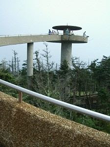
At 8:35am I was standing on Clingmans Dome. The weather was fantastic. Clear sky’s, 68 degrees, and the view was amazing. I ran down the winding ramp that leads up to Clingmans Dome and turned right on the AT. For the next 8 miles I ran up and down to reach New Found Gap. This would be the only access point to a road for the entire day. I topped off the water bottle I consumed in the last 8 miles and kept heading North East on the AT. I was carrying 3.5 liters of water and some food in a day pack.

Reputedly known as "Kuwahi" (the mulberry place) by the Cherokee Indians, the mountain was originally dubbed "Smoky Dome" by local Scots-Irish inhabitants. In 1859, the mountain was henceforth renamed for Thomas Lanier Clingman (1812-1897), who extensively explored the area in the 1850s and spent many years thereafter promoting it and was also a lawyer, member of the U.S. Congress (House and Senate), and a brigadier general for the Confederate States of America, by compatriot Arnold Guyot. Guyot named the mountain for Clingman due to an argument between the U.S. Senator and a professor at the University of North Carolina, Elisha Mitchell over which mountain was actually the highest in the region. Mitchell contended that a peak by the name of Black Dome (now known as Mount Mitchell) was the highest, while Clingman asserted that Smoky Dome was instead the true highest peak. Guyot put the dispute to rest when finding that Smoky Dome was 39 feet (12 m) shorter than Black Dome.

After passing the Boulevard Trail that leads up to Mt. LeConte the AT runs along one of he most amazing ridges I have ever hiked on. At this point in my adventure I was alone, and continued to be alone for the rest of the run.

2 hours into the run I was at New Found Gap, 5 hours into the run I was at Pecks Shelter, 6.5 hours I was at TriCorners, 10:58 I was at Davenport Gap. It rained during the middle of the day, but overall the weather was very nice. I consumed 7 liters of water, and ate a little over 1,000 calories which is not enough for a run like this. My heart rate monitor told me I burend over 9,000 calories in my 10:58 of running.

Wednesday, September 19, 2007

Smokey's 60k Preview

This Saturday I will be running one of my favorite trails in the South East, the AT in the Smokey’s. I have done the 31 mile section from Newfound Gap several times and want to go a little farther this time and will start at Clingmans Dome (37 miles). Clingmans Dome is the western terminus to the Mountains to Sea Trail that begins and is the highest point in the Smokey Mountains at 6,643 feet. Only Mt. Mitchell rises higher east of the Mississippi.

Myself and a few friends from Charlotte plan to get an early morning start. We can drop some aid at Newfound Gap which is six miles away from the start. Once we pass Newfound Gap there will be no aid stations and the run will be 100% self supported. The weather can be very tricky in this area, but so far we are looking at a fantastic Saturday.

Wednesday, September 12, 2007

Ramadan Is Here

Thursday the 13th of September is the first day of Ramadan. It is a month of fasting for Muslims around the globe from sunrise to sunset for a full lunar month. It is not only about fasting from food and water, its about being good, moral peace keeping people. More importantly, it is a bout a spiritual purification that comes from being deprived of the basic necessities of life in order to appreciate the blessing bestowed upon us, and to realize that there are people worse off, and that it is our duty to aid them. It can be seen as a detoxification period that trains the body and mind.

You can’t run very far without water or food. So how does this affect my training? Ill be running a lot at night.

Sunday, September 09, 2007

Table Rock to Montreat - 39 Miles

Table Rock to Montreat is a run from the summit of Table Rock that follows the Mountain to Sea Trail to the Black Mountain Campgrounds and then is run down to the city of Montreat. Planned and organized by Adam Hill, a friend, and an unltramarathoner. Many thanks to the volunteers that helped with the aid station and with the entire logistics of putting on a long distance point to point run.

After meandering our way thru the gravel roads that lead to Table Rock, we all unloaded our gear and started packing essentials for the night and everything we needed for the next morning.

Nine runners and a few volunteers all hiked up to the summit of Table Rock (3,680 feet). It was a perfect night, the stars were bright. After seeing a shooting star, and Brown Mountain light up a few times I shut my eyes and passed out around midnight. We woke up at 5:30am, gathered everything, and at 6am started running back down the mountain. Our cars were along the way which is where I dropped off my sleeping bag and pad. We continued along the Mountains to Sea trail (MST). It would be 11 miles before we would reach our first aid station.

The views along the ridge off of Table Rock in the morning made me feel like I was out West. As the sun started to rise, and faint red glow was painted along the horizon. We headlamped it for the first hour. I wasn’t expecting it to be so hot before the sun came up, I remember being drenched in sweat as we passed Chimney Gap and the sun wasn’t even up yet! Approaching Shortoff Mountain (2,880 feet) I couldn't help but notice how much of the forest had burned. The trail blazes and the trail itself was also burned, making the route difficult to find at times. My legs, and arms were black with char all over my body. We descended steeply down Shortoff and climbed towards Pinnacle were the green forest came back to life. We climbed 1,200 feet in less than a mile to reach the top of Pinnacle (2,400 feet). Atlast the first aid station! I needed some calories and certainly needed to fill up my bottles.

After refueling, me and Marc descended down the Overmountain Victory trail for a short while, then turned left on a gravel road. It was here I kept telling myself that this would be a long day, and not to push myself too hard. I alternated the running with some brisk hiking, it was becoming very hot. I then passed Dobson Knob (3,440 feet) and then Bald Knob (3,495 feet), kept going up and down. I was rationing my water as I knew I still had to pound out a few miles. I had been running alone for the past 2 hours at this point. When I reached a set of train tracks I made the mistake of turning as I remember seeing a sign to the left. This was a mistake. I ran and hiked down the train tracks for half a mile in the exposed sun. I realized there must be something wrong and decided to take a water break and sit down in the shade and pull out my map. I could hear and see the river, and I made it out in the map. I decided at this point to start bushwhacking back to the trail. I had already lost too much precious time, and I needed to get to the next aid as I didn’t have much water left. I picked up to sticks and used them to cut thru some of the vegetation while trying to cross. I crossed the river, again getting my feet wet. Then crossed a nasty swamp and climbed up some steep section which is where I heard voices. I started to yell out and sure enough it was Rob. I started whacking more vegetation trying to get closer to his voice. I made it back to the trail, but now out of water and exhausted. I took a sip of water from Rob and kept moving, we still had another mile and half to the next aid. After crossing a 5 lane highway (221) I finally reached the second aid station. I drank a cold coke which never tasted so good. Ate a cheese sandwich and took my socks and shoes off. I had another pair of socks I would put on. At this point I was ready to drop out of the run. After taking a 15 minute break, Rob talked me into getting back on the trail. We had run 26 miles at this point, well if you factor all the bushwhacking, maybe 27, and the next section would be another 13 miles, much of it uphill. I was up for the challenge, re-laced my shoes and pushed on.

We walked passed Grassy Knob (1,800 feet) pulled the map out a few times to find out way up to Woods Mountain (3,646 feet). We turned left and ridge hiked after passing Woods and alternated with the running and fast hiking. It was here we met Marc again on the trail and kept moving as a group of three now. Then just a mile before John a volunteer met us out on the trail with Gatorade. Wow, I was relieved. I had been practicing Sip Control Management for the past 3 hours. This was a strict policy of one sip every 12 minutes. If I took in more than that, I would go dry and suffer miserably with the heat. So when I saw the cold blue Gatorade that John brought out and he was giving it out to us, I guzzled down when I had and refilled my bottle of water. He told us we had 30 min, which also psyched me out, so we kept pushing. I ran to the end until I got to the BRP and Hwy 80. I was beat up, dehydrated, but very happy I had gone this far. The temperatures must have been in the 90’s and going for 40 miles and climbing no less than 8,000 feet was a difficult task for me to do. All runners dropped out at this point.